PRESENTATION ARCHIVE
OVERVIEW
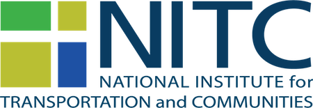
The aim of this research is to investigate pedestrian behavior at signalized intersections using state-of-the-art LIDAR sensing technologies and to use this data, along with vehicular data, to develop a more effective multimodal signal control system.
In the presentation, the presenters will describe a novel method of collecting pedestrian crossing behaviors at signalized intersection, discuss the findings and implications of data analytics, and introduce a novel approach to dynamic flashing yellow arrow mechanisms to reduce the conflict between left turn vehicles and crossing pedestrians.
KEY LEARNING OUTCOMES
- Understand the framework of LiDAR sensing solutions;
- Understand how to collect pedestrian behaviors at intersections;
- Understand how to provide new protection for crossing pedestrians with object-tracking technologies.
THE RESEARCH
This webinar is based on a study funded by the National Institute...
Read more
PRESENTATION ARCHIVE
OVERVIEW
Conventional four-step travel demand models are used by nearly all metropolitan planning organizations (MPOs), state departments of transportation, and local planning agencies, as the basis for long-range transportation planning in the United States. A flaw of the four-step model is its relative insensitivity to the so-called D variables. The D variables are characteristics of the built environment that are known to affect travel behavior. The Ds are development density, land use diversity, street network design, destination accessibility, and distance to transit. In this seminar, we will explain how we developed a vehicle ownership model (car shedding model), an intrazonal travel model (internal capture model), and mode choice model that consider all of the D variables based on household travel surveys and built environmental data for 32, 31, and 29 regions, respectively, validates the models, and demonstrates that the models have far better predictive accuracy than Wasatch Front Regional Council (WFRC)/Mountailand Association of Governments’ (MAG) current models.
In this webinar, researchers Reid Ewing and Sadegh Sabouri will...
Read more
PRESENTATION ARCHIVE
OVERVIEW
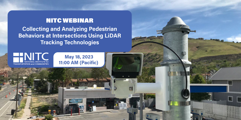
Transportation systems play a critical role in maintaining supply chains for effective post-disaster recovery. Modeling the potential economic impact of transportation-related disruptions, therefore, is an important step to promoting pre-event communitywide recovery and resilience planning. But existing supply chain and economic impact models are cost prohibitive and overly sophisticated for use by public sector entities with limited resources. There is also limited understanding of how small and medium enterprises (SMEs) adjust to post-disaster transportation disruption and how this experience influences their future preparedness for similar events. Since SMEs make up a majority of businesses within the US, post-disaster transportation loss can significantly affect the local economy and the recovery trajectory for the entire community.
This project has two objectives:
- To develop a collaborative university-community partnership framework for analyzing the economic impact due to transportation disruptions in earthquake country
- To examine SME preparedness to such managing such disruptions...

PRESENTATION ARCHIVE
OVERVIEW
This presentation introduces an innovative spatiotemporal analytical framework and web-based visualization platform developed by researchers at the University of Utah to assist transit agencies in identifying optimal deployment strategies for a battery-electric bus (BEB) system by using a combination of mathematical programming methods, GIS-based analysis, and multi-objective optimization techniques. The framework allows transit agencies to optimally phase in BEB infrastructure and deploy the BEB system in a way that can minimize the capital and operational cost of the BEB system while maximizing its environmental benefits (i.e., emission reduction).
KEY LEARNING OUTCOMES
- Introduction to a bi-objective spatiotemporal optimization model for the strategic deployment of BEBs to minimize the cost of purchasing BEBs, on-route and in-depot charging stations, and to maximize environmental equity for disadvantaged populations.
- The optimization considers the unique constraints imposed by BEB...
PRESENTATION ARCHIVE
OVERVIEW
Older adults often face challenges with mobility and accessibility, which can limit their independence and quality of life. This seminar will explore these issues and lessons learned from the research to improve travel experiences and satisfaction for older adults.
KEY LEARNING OUTCOMES
- Highlights the importance of considering diverse dimensions of older adults' needs.
- Found a significant dissatisfaction and vulnerability experienced by older adults with limited mobility.
- Identified the need for addressing the critical accessibility and mobility gaps with older adults.
THE RESEARCH
This webinar is based on a study funded by the National Institute for Transportation and Communites (NITC) and conducted at the University of Utah. Read more about the project: Transportation for Seniors (T4S): Developing a New Accessibility Measure to Support Older Adults in a Post-Pandemic World.
SPEAKERS
Andy Hong, University of Utah...
Read more
PRESENTATION ARCHIVE
OVERVIEW
This webinar will demonstrate the tremendous value of GPS trajectory data in understanding statewide travel patterns and measuring performance. First, Dr. Markovic (U of Utah) will conduct visual exploration of GPS trajectories that capture about 3% of all the trips in Utah. He will briefly discuss the problem of scaling GPS trajectories to the population, and then focus on the use of scaled trajectories in computing origin-destination matrices, vehicle-hours delays, vehicle-miles traveled, and trip-based performance measures. Second, Dr. Franz (CATT Lab) will demonstrate a suite of visual analytics that enables transportation agencies to easily explore terabytes of GPS trajectory data. He will demonstrate different tools and share the experience of 5 state DOTs that are currently using CATT Lab's trajectory data suite.
KEY LEARNING OUTCOMES
- Trajectory data represents the most complete vehicle-probe data and provides unprecedented opportunity for transportation system analysis.
- Transportation agencies can easily leverage visual analytics to obtain insights in statewide traffic patterns and...
PRESENTATION ARCHIVE
- Miss the presentation or want a look back at the slides? You can view them here.
- Watch the recorded video
Small towns and cities outside of national parks and other major natural amenities throughout the western United States are becoming increasingly popular places to visit and live. As a result, many of these gateway and natural amenity region (GNAR) communities—including places such as Jackson, Wyoming, and Moab, Utah—are facing a variety of “big city” issues, such as severe congestion, lack of affordable workforce housing, and concerns about sprawl and density. This webinar will introduce the planning and transportation concerns being experienced by GNAR communities throughout the west. It will then share the tools and resources developed by the University of Utah to train planners to work in these unique communities and to help these communities enhance livability and sustainable transportation options. The webinar will also introduce the University of Utah’s new Gateway and Natural Amenity Region Initiative and ongoing research aimed at better understanding and addressing the planning and transportation issues in GNAR communities.
... Read more
PRESENTATION ARCHIVE
OVERVIEW
Multimodal transportation systems (e.g., walking, cycling, automobile, public transit, etc.) are effective in increasing people’s travel flexibility, reducing congestion, and improving safety. Therefore, it is critical to understand what factors would affect people’s mode choices. With advanced technology, such as connected and automated vehicles, cities are now facing a transition from traditional urban planning to developing smart cities. To support multimodal transportation management, this study serves as a bridge to connect speed management strategies of conventional corridors to connected vehicle corridors.
The study consists of three main components. In the first component, the impact of speed management strategies along traditional corridors was evaluated. In the second component, the impacts of the specific speed management strategies, signal retiming and...
Read more